Überschreitung Siplinger Kopf - Heidenkopf - Girenkopf - wenig bekannte Gratwanderung im Allgäu
891 بار بازدید -
-
This fantastic hike in the
This fantastic hike in the Allgäu, past the impressive Siplinger Nadel with subsequent crossing of the beautiful ridge trail from Siplinger Kopf to Girenkopf, many have not even on the radar, but it is an absolutely worthwhile tour, both scenically and from the experience factor. Especially the ridge path requires sure-footedness and occasionally a head for heights, as well as the love for scrambling :)
Start / Finish: Hikers' parking lot in Gunzesrieder Tal /Aubachtal a bit along the toll road
Distance: 10 km
Meters in altitude: 800
Duration: 5-6 hours
Type: round tour
Difficulty: medium; technically easy, rope-secured passages on the ridge trail as well as occasionally narrow exposed paths; away from the ridge trail the paths are not difficult
Start was for us in the rear Gunzesrieder Tal /Aubachtal, we follow the toll road to a small parking lot for hikers.
First it goes over a wider path in steep switchbacks through a beautiful mixed forest. Then it continues over very idyllic meadow paths, the landscape here is already fantastically beautiful and from the valley basin you can see the whole further course of the tour.
Slightly to the left and more steeply uphill we come to the first highlight, the Siplinger Nadel, a rock formation made of the Nagelfluh rock typical here. Passing the needle, we reach a first ridge path, which shortly after leads us over hundreds of wooden steps up to the Siplinger Kopf (1746m). From here you have a fantastic panoramic view.
From here on the path becomes surprisingly exciting, it always goes along the ridge, partly over rope-secured steep steps down and up, which are never particularly difficult.
Nevertheless, a few places are quite exposed and can also be dangerous, especially in wet conditions, so be careful here accordingly.
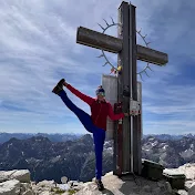
Not far after the Siplinger Kopf we reach the Heidenkopf with its small summit cross. Continuing on the ridge path, there are always short, rope-secured rock steps as well as a fork in the path and in about 30 - 40 minutes we reach the third summit, the Girenkopf.
The even smaller summit cross is unfortunately not accessible behind a wire fence.
We now walk back for about 20 minutes to the fork in the path and from here downhill to the Scheidwang Alpe. The path is easy and slightly descending mostly over meadow paths. The Scheidwang Alpe seems to be no longer managed. From there, take the asphalt road back to the parking lot.
Start / Finish: Hikers' parking lot in Gunzesrieder Tal /Aubachtal a bit along the toll road
Distance: 10 km
Meters in altitude: 800
Duration: 5-6 hours
Type: round tour
Difficulty: medium; technically easy, rope-secured passages on the ridge trail as well as occasionally narrow exposed paths; away from the ridge trail the paths are not difficult
Start was for us in the rear Gunzesrieder Tal /Aubachtal, we follow the toll road to a small parking lot for hikers.
First it goes over a wider path in steep switchbacks through a beautiful mixed forest. Then it continues over very idyllic meadow paths, the landscape here is already fantastically beautiful and from the valley basin you can see the whole further course of the tour.
Slightly to the left and more steeply uphill we come to the first highlight, the Siplinger Nadel, a rock formation made of the Nagelfluh rock typical here. Passing the needle, we reach a first ridge path, which shortly after leads us over hundreds of wooden steps up to the Siplinger Kopf (1746m). From here you have a fantastic panoramic view.
From here on the path becomes surprisingly exciting, it always goes along the ridge, partly over rope-secured steep steps down and up, which are never particularly difficult.
Nevertheless, a few places are quite exposed and can also be dangerous, especially in wet conditions, so be careful here accordingly.
Not far after the Siplinger Kopf we reach the Heidenkopf with its small summit cross. Continuing on the ridge path, there are always short, rope-secured rock steps as well as a fork in the path and in about 30 - 40 minutes we reach the third summit, the Girenkopf.
The even smaller summit cross is unfortunately not accessible behind a wire fence.
We now walk back for about 20 minutes to the fork in the path and from here downhill to the Scheidwang Alpe. The path is easy and slightly descending mostly over meadow paths. The Scheidwang Alpe seems to be no longer managed. From there, take the asphalt road back to the parking lot.
55 سال پیش
در تاریخ 1403/04/21 منتشر شده
است.
891
بـار بازدید شده