Intense Severe Thunderstorm in Leander/Cedar Park, TX - 6/4/2018
77 هزار بار بازدید -
6 سال پیش
-
After a long period of
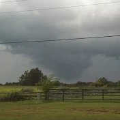
After a long period of what seemed like a thunderstorm extinction in Central Texas, the Storm Prediction Center issued a marginal risk for severe thunderstorms in the area, mostly for damaging winds. Towards the evening, a mesoscale convective system began to move in from eastern Texas and headed westward towards the Austin area, reaching the Central Texas area by around 11:00 PM. At around 11:45 PM, the National Weather Service issued a Severe Thunderstorm Warning for eastern Williamson County for 60 mph wind gusts and nickel-sized hail. Once the complex reached northern Travis County, it began to stall over the metro area due to the presence of multiple boundaries that stopped the system in its tracks, dropping 4+ inches of rain in places such as Pflugerville, TX with the NWS issuing multiple flash flood warnings. Areas such as Pflugerville and Round Rock also lost power for many hours due to the storm system, with wind damage reports scattered all across the Central Texas area. This storm system was also notable for having an astounding amount of cloud-to-ground lightning, which also caused damage and power outages.
Satellite imagery of the developing storm complex:
Twitter: 1003521935941070853
Satellite imagery from NWS WPC showing how strong the updrafts were from the MCS and how it combined with another MCS coming from West Texas:
Twitter: 1003497817032282112
Twitter: 1003777612555194369
NWS Austin/San Antonio issuing the first flash flood warning:
Twitter: 1003518028976414720
KVUE & KXAN's reports on the storm system:
https://www.kvue.com/article/weather/...
http://www.kxan.com/news/local/austin...
KXAN's report on the power outages caused by the storm complex:
http://www.kxan.com/news/local-news/p...
6 سال پیش
در تاریخ 1397/03/14 منتشر شده
است.
77,012
بـار بازدید شده