Trimble SiteVision - Lidar and Radio detection
193 بار بازدید -
2 ماه پیش
-
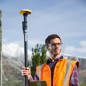
Why limit yourself to scanning
Why limit yourself to scanning below-ground when you can also capture above-ground data with SiteVision?
With a simple mount, you can leverage the iPhone's LiDAR to continuously scan the terrain while searching for utilities. SiteVision offers the capability to store a comprehensive point cloud of the area and track your search progress in real-time. Combined with remote measurement, this eliminates the need for the traditional survey rod. The integration of 3D models and AR provides a thorough and detailed view of the site.
Excited to see more underground utilities being mapped and the enhanced use of point cloud capabilities in GIS!
(Full disclosure: SiteVision was not connected via Bluetooth to the RD)
@TrimbleGeospatial
@trimblesitevision1026
LinkedIn: guillaume-clin
2 ماه پیش
در تاریخ 1403/03/31 منتشر شده
است.
193
بـار بازدید شده