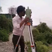
Cadastral map(mouza map) scalling with auto cadd
14.6 هزار بار بازدید -
6 سال پیش
-
How to know about mentioned
How to know about mentioned scale on cadastral map and how to use a mentioned scale for measurement, scaled full cadastral map,and plotting a survey datascale, autocad, cad, map, dwg, london, plan, choose, window, easy, change, where, what, show, computer, university, auto, file, drawing, fit, print, make, mm, unit, software, technology, 5000, to, to1:5000, how, plot, digimap, 2010, scale image with reference, insert image and scale, insert image, scale reference, how to scale an image, scale image, import image jpeg
6 سال پیش
در تاریخ 1397/03/20 منتشر شده
است.
14,622
بـار بازدید شده