Civil 3D: Importing KML and KMZ files with coordinate system transformations, lat-lon→ Local system
123 بار بازدید -
هفته قبل
-
https://For those who want to
https://For those who want to explore the attribute data that can be assigned to each polyline (primitive).If you already have a KML file, you can skip the first 60 sec of the video, which explains how to get data to create a KML.
00:01 Download the routing of Australia
00:08 Unpacking the archive Australia.zip
00:11 GPSMapEdit opens for Australia.mp
00:14 Zoom in on the required area of the map (Z button or CTRL+wheel)
00:23 Press 0 (zero) and turn on the most detailed layer
00:32 Select the necessary section of the routing card
00:39 Creating a new workspace in the GPSMapEdit program
00:45 Disable OSM background (or Google, Bing)
00:49 Inserting a copied section of the city
00:54 Zoom in on the required area of the map
00:59 Export to KMZ
01:12 Switch to the workspace "Planning and analysis"
01:18 Loading the coordinate system using the EPSG code: 4326 (LL_WGS84)
01:32 Import the KMZ file (_.MAPIMPORT)
01:43 Select the attributes we need to sign each line
01:51 Select the kml_name attribute
01:53 In my file, all lines from the KMZ file are imported only to the Placemark ayer
01:59 Creating/configuring attribute imports for points
02:07 Create/configure attribute import (kml_name) for routing
02:11 What happens if you select import of all attributes I will show at the end of 0:0he video
02:16 Routing. Import progress
02:21 Double-click the mouse wheel to find the imported routing lines
02:25 Brisbane is the only point of import
02:29 how OD attributes are displayed in properties: (kml_name = Legacy Way)
02:35 Save the file
02:40 Copy the value for the file name (Ctrl+C "Brisbane")
02:44 Saving a file (Ctrl+Shift+S)
02:50 Creating a new file (Brisbane.dwg)
03:00 I assign a new coordinate system to the new file
03:12 In my case, the local coordinate system of the city
03:16 Now you need to convert the world coordinates to the local system WGS84 → ocal 0:0system
L3:21 switch back to the "Civil 3D" workspace
03:25 Turn on coordinate tracking and the MAP taskbar (MAPWSPACE)
03:31 MAPWSPACE - ON (on panel display)
03:34 Right-click on the "Current query" line
03:37 Define
03:39 Boundary type - "ALL"
03:43 "Query mode" is now available
03:46 Uploading the "drawings"
03:49 Adding the original drawing for transformation to the local coordinate system
04:03 "Execute query "for coordinate transformation
04:11 We observe that now the coordinates are not global (WGS84) - but Cartesian 0:0local
04:17 Have drawn a rectangle around the extreme points of the site to show how it has expanded
04:24 Copy from the base point (Ctrl+Shift+C)
04:29 Inserted a rectangle into the original drawing and noticed that there were some distortions when the coordinate system used for the drawing was latitude-longitude.
04:36 What happens if you select all the attributes of OD, and not one kml_name
04:51 There will be a lot of attributes
To break the link with the original drawing, copy the data from the base point to another new drawing
Another project with open data around the world (well, almost)):
https://stadiamark.com/ , the project that distributes for free geographic data of routing OpenStreetMap routing all over the world
There are many offline routing services using OpenStreetMap data. One of them is the
GPSMapEdit Portable: windows11downloads.com/win11-gpsmapedit-portable/
I use OSM maps as a background, and of course, you can convert the coordinates of not only polylines but also points and polygons, all following a similar process.
For those who want to explore the attribute data that can be assigned to each polyline (primitive). A website where you can find out more about OD attributes, learn how to edit and copy them :
odclass-odedit.com/index.html - editing and analysis of descriptive data
If you need to convert, prepare, or analyze data (points, polylines, and polygons) for your project, please do not hesitate to contact me. (gmail). Alternatively, if you need to create and analyze a digital elevation model (DEM) based on approximately such data sources:
• ALOS Global Digital Surface Model — 30m (AW3D30)
• SRTM 90m (3") Digital Elev Database
To Create Cross Sections To Analyze Material Quantities
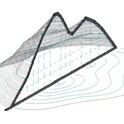
Surface analysis:
• Directions. Used for aspect analysis. Renders surface triangles differently according to the direction they face.
• Elevations. Used for elevation banding analysis. Renders surface triangles differently according to their elevation range.
• Slopes. Renders surface triangles differently according to the slope range they fall within.
• Slope Arrows.
• Contours.
• User-Defined Contours.
• Watersheds.
• Contour Problems.
• Water Drop. Used to trace the path that water would take across a surface.
• To Calculate Surface Catchment Areas
https://stadiamark.almagest.name - Apps for construction: earthworks and road work. Упрощение рутинных расчетов
00:01 Download the routing of Australia
00:08 Unpacking the archive Australia.zip
00:11 GPSMapEdit opens for Australia.mp
00:14 Zoom in on the required area of the map (Z button or CTRL+wheel)
00:23 Press 0 (zero) and turn on the most detailed layer
00:32 Select the necessary section of the routing card
00:39 Creating a new workspace in the GPSMapEdit program
00:45 Disable OSM background (or Google, Bing)
00:49 Inserting a copied section of the city
00:54 Zoom in on the required area of the map
00:59 Export to KMZ
01:12 Switch to the workspace "Planning and analysis"
01:18 Loading the coordinate system using the EPSG code: 4326 (LL_WGS84)
01:32 Import the KMZ file (_.MAPIMPORT)
01:43 Select the attributes we need to sign each line
01:51 Select the kml_name attribute
01:53 In my file, all lines from the KMZ file are imported only to the Placemark ayer
01:59 Creating/configuring attribute imports for points
02:07 Create/configure attribute import (kml_name) for routing
02:11 What happens if you select import of all attributes I will show at the end of 0:0he video
02:16 Routing. Import progress
02:21 Double-click the mouse wheel to find the imported routing lines
02:25 Brisbane is the only point of import
02:29 how OD attributes are displayed in properties: (kml_name = Legacy Way)
02:35 Save the file
02:40 Copy the value for the file name (Ctrl+C "Brisbane")
02:44 Saving a file (Ctrl+Shift+S)
02:50 Creating a new file (Brisbane.dwg)
03:00 I assign a new coordinate system to the new file
03:12 In my case, the local coordinate system of the city
03:16 Now you need to convert the world coordinates to the local system WGS84 → ocal 0:0system
L3:21 switch back to the "Civil 3D" workspace
03:25 Turn on coordinate tracking and the MAP taskbar (MAPWSPACE)
03:31 MAPWSPACE - ON (on panel display)
03:34 Right-click on the "Current query" line
03:37 Define
03:39 Boundary type - "ALL"
03:43 "Query mode" is now available
03:46 Uploading the "drawings"
03:49 Adding the original drawing for transformation to the local coordinate system
04:03 "Execute query "for coordinate transformation
04:11 We observe that now the coordinates are not global (WGS84) - but Cartesian 0:0local
04:17 Have drawn a rectangle around the extreme points of the site to show how it has expanded
04:24 Copy from the base point (Ctrl+Shift+C)
04:29 Inserted a rectangle into the original drawing and noticed that there were some distortions when the coordinate system used for the drawing was latitude-longitude.
04:36 What happens if you select all the attributes of OD, and not one kml_name
04:51 There will be a lot of attributes
To break the link with the original drawing, copy the data from the base point to another new drawing
Another project with open data around the world (well, almost)):
https://stadiamark.com/ , the project that distributes for free geographic data of routing OpenStreetMap routing all over the world
There are many offline routing services using OpenStreetMap data. One of them is the
GPSMapEdit Portable: windows11downloads.com/win11-gpsmapedit-portable/
I use OSM maps as a background, and of course, you can convert the coordinates of not only polylines but also points and polygons, all following a similar process.
For those who want to explore the attribute data that can be assigned to each polyline (primitive). A website where you can find out more about OD attributes, learn how to edit and copy them :
odclass-odedit.com/index.html - editing and analysis of descriptive data
If you need to convert, prepare, or analyze data (points, polylines, and polygons) for your project, please do not hesitate to contact me. (gmail). Alternatively, if you need to create and analyze a digital elevation model (DEM) based on approximately such data sources:
• ALOS Global Digital Surface Model — 30m (AW3D30)
• SRTM 90m (3") Digital Elev Database
To Create Cross Sections To Analyze Material Quantities
Surface analysis:
• Directions. Used for aspect analysis. Renders surface triangles differently according to the direction they face.
• Elevations. Used for elevation banding analysis. Renders surface triangles differently according to their elevation range.
• Slopes. Renders surface triangles differently according to the slope range they fall within.
• Slope Arrows.
• Contours.
• User-Defined Contours.
• Watersheds.
• Contour Problems.
• Water Drop. Used to trace the path that water would take across a surface.
• To Calculate Surface Catchment Areas
https://stadiamark.almagest.name - Apps for construction: earthworks and road work. Упрощение рутинных расчетов
هفته قبل
در تاریخ 1403/04/06 منتشر شده
است.
123
بـار بازدید شده